Biodiversity and ecosystems
Mike Rawitch
April 11, 2023
How satellites are helping legacy landowners
Across the USA, there are over 40,000 large tracts of land requiring careful management to clean up hazardous waste including heavy metals, hydrocarbons, and other organic chemicals. Known also as superfund sites or legacy land sites, these sites can be both dangerous and hazardous. Additionally, these sites require maintenance to prevent land deterioration.
Legacy mine and drilling site owners and operators, superfund site operators, innovation managers, and environmental technology managers are typically in charge of these responsibilities. This group can be described as environmental remediation site owners.
Legacy land site issues
Legacy land sites expose the environment to toxic and harmful chemicals, they create physical hazards such as sinkholes, and they impact air quality and threaten human health. Especially if something goes wrong at a site, there’s a significant environmental and human risk potential, a high cost for remedial actions, and potential legal liability.
While it is very difficult to repair environmental damage if problems are discovered too late or left too long. Therefore, environmental remediation stie owners are mandated to monitor land regularly.
However, land characteristics change every day. It’s difficult to assess if a changing landscape is a sign of stability and health, or a sign of issues and danger.
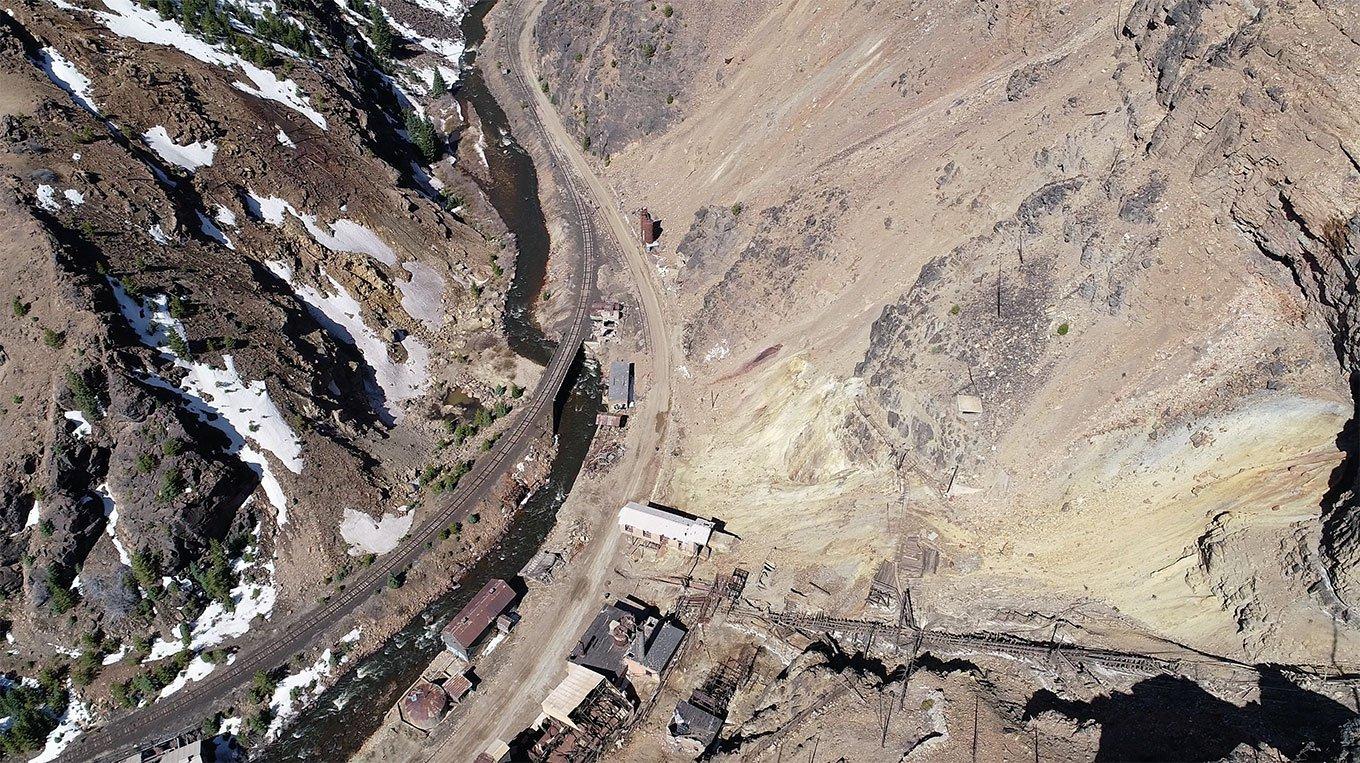
Potential Surface Staining
The responsibility of site owners
To make matters more challenging for environmental remediation site owners, traditional techniques for monitoring land is expensive, time-consuming, and inherently inaccurate.
Traditional techniques rely on surveyors and manual processes to track vast swathes of land at ground-level. The four problems with this are:
- Key information can be missed
- Subtle land changes are hard to identify and often noticed too late
- Parts of land are missed altogether because they are too remote to access
- In pandemic situations, like COVID-19, field operations are at a standstill
How new satellites help
Satellite and aerial imagery can be used to effectively monitor land, to take inventory of a site, digitise the inventory data, and create a 3D topographic map.
From there, our artificial intelligence-powered platform characterises vegetation coverage by density, distribution, and habitat type to identify signs of land contamination, erosion, and hydrologic issues.
Until recently, Earth observation (EO) satellites were mainly used and operated by governments or public organisations. These satellites circle the Earth continuously to collect high-resolution, multispectral imagery data. In the past, only some data was made publicly available, and at a high price.
Fortunately, satellite imagery data is more prevalent than ever, and its quality has dramatically improved. Today, many companies have access to EO satellites and the data they provide due to a decrease in payload costs and satellite size. The deployment of more commercial satellites is a trend with no end anytime soon.
The newer satellites in operation today provide higher resolution imagery in comparison to earlier generations, and they can fly over Earth more regularly including over certain locations more than once a day.
The benefits of satellite imagery
Satellites are successfully deployed in both spectral and morphological analyses of hazardous waste on legacy land sites. The imagery they produce includes information on related to spectral, spatial, and temporal resolutions.
Spectral resolutions provide statistics to help us classify images. Spatial resolutions allow for accurate identification of ground objects. Temporal resolutions help generate land coverage maps for activities such as environmental planning, site detection, and transportation planning.
Many refer to satellite data as remote sensing data, partly because of its ability to monitor previously inaccessible pieces of land. Regardless of its name, this data provides key information to help monitor applications such as image fusion, change detection, and land cover classification.
This is good news for environmental site managers or natural resource managers. It allows them to:
- Inspect archive data to show trends in the landscape from a bird’s-eye perspective
- Remotely capture data across an area and quantitatively measure how the landscape changes
- Measure and understand how tracts of land change over time regarding vegetation parameters
- Make more holistic, accurate, and data-driven decisions in a timely manner
In short, site owners can now access pictures of their property on demand.
The next generation of land management
Today, landowners and managers can see measurements across their entire landscape and monitor data trends over time without leaving their desk. They can quickly report the status - its progress or regression - of their site to stakeholders and regulators without spending as much time and money on in-field checks.
Satellite imagery does not completely replace manual surveys. It is worth validating satellite imagery with occasional on-the-ground inspections to ensure reliability. However, platforms like Galago present site owners with a clear overview of what’s happening on their land so they can use resources more efficiently. Such an overview comes with a high degree of accuracy never been seen before.
With these new generation of technology, environmental site managers and legacy landowners no longer must solely rely on ground-based vegetation surveys. Instead, they can use data and analytics to pinpoint how they allocate their resources, ultimately saving themselves time and money.
Interpreting and analysing satellite data
To support landowners and managers, the Galago team uses satellite and drone imagery to turn sites into digitised maps. Then, using an AI platform, analyses sites to give landowners a baseline to identify changes over time. Galago’s AI platform and algorithms are based on decades of datasets to ensure recommendations are both accurate and extensive.
As far as user experience goes, anyone managing land assets can use the Galago platform. The platform is designed for users to easily receive a complete report showing if, where, and how their land is deteriorating as well as provide recommendations for next actions.
Moreover, the platform sends an alert to landowners and managers when issues arise on their site. This can prevent or mitigate future restoration costs, strengthen relationships with authorities, and give site owners concrete evidence for any litigation challenges.
What’s next for satellite-based sustainable land management?
Satellite data analytics have changed the way we manage land, and this will only continue as technologies gets better and their costs get lower. Best yet, easy-to-use platforms like the one from Galago will continue to help site managers and legacy landowners interpret and use the imagery effectively.